Supply Chain Concerns
While reading about supply chains and food, I became fascinated by the transport on the Mississippi River. Most of the grains, corn and soy, grown in the Midwest travel down the river to the Gulf of Mexico, where they are exported around the world. I spent far too long this weekend reading about barges and tugboats, and the challenges of the Upper Mississippi River with locks and low water levels.
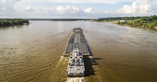
Tugboats push barges as in the picture above. As they travel down the river, the barges transport mostly soy and corn and some wheat; and sometimes carry non-food goods. Travel up river, which is harder, the barges often travel empty and they also transport fertilizer, sand, and gravel.

The Mississippi River System (MRS)
I used to live about a mile from the Mississippi in St Paul MN, where it is the boundary between St Paul and Minneapolis. My side of the river was a recreational area with bluffs with trails for hikers and cyclists. I often cycled down Grand Ave, past St Kates (St Katharine’s University) and along the river. The best memory I have was in winter, the river partly frozen and a golden eagle eating an orange salmon on a beach, while harassed by ravens. When the black birds got too close, the eagle spread its wings. It was like me flapping away a mosquito. Ravens might be big black birds, but the eagle was bigger and it knew it. Majestic while eating dinner.
In American culture, the Mississippi forms the border between Eastern and Western US, except I don’t recommend telling any residents of any city west of Buffalo that they are part of the East. I remember my friends in Cleveland OH, insisting that they weren’t “east” despite a map saying otherwise.
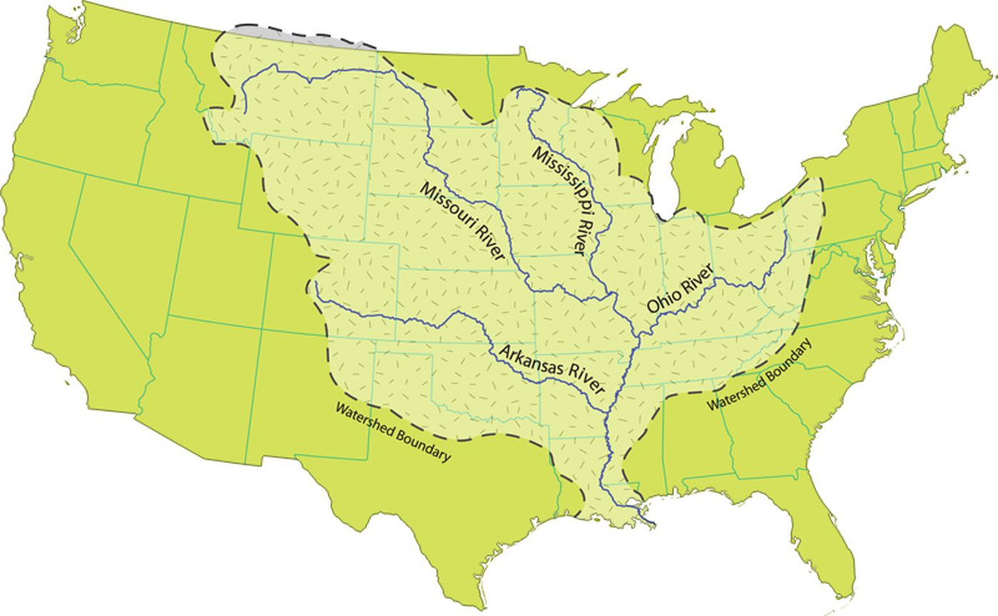
The river essentially cuts the country in half and drains it drains all or parts of 32 states and two Canadian provinces. The total the total drainage basin is 1,151,000 square miles (2,980,000 km2), of which only about one percent is in Canada.

The Mississippi River System (MRS) stretches from Minnesota to Louisiana with other major rivers, including the Missouri, the Illinois, the Ohio, and the Arkansas; feeding into the Mississippi and adding to its river traffic. If you were a drop of water entering the river at its source, you would take three months to get to the Gulf of Mexico.
We divide the river system into three distinct regions:
The Upper Mississippi River
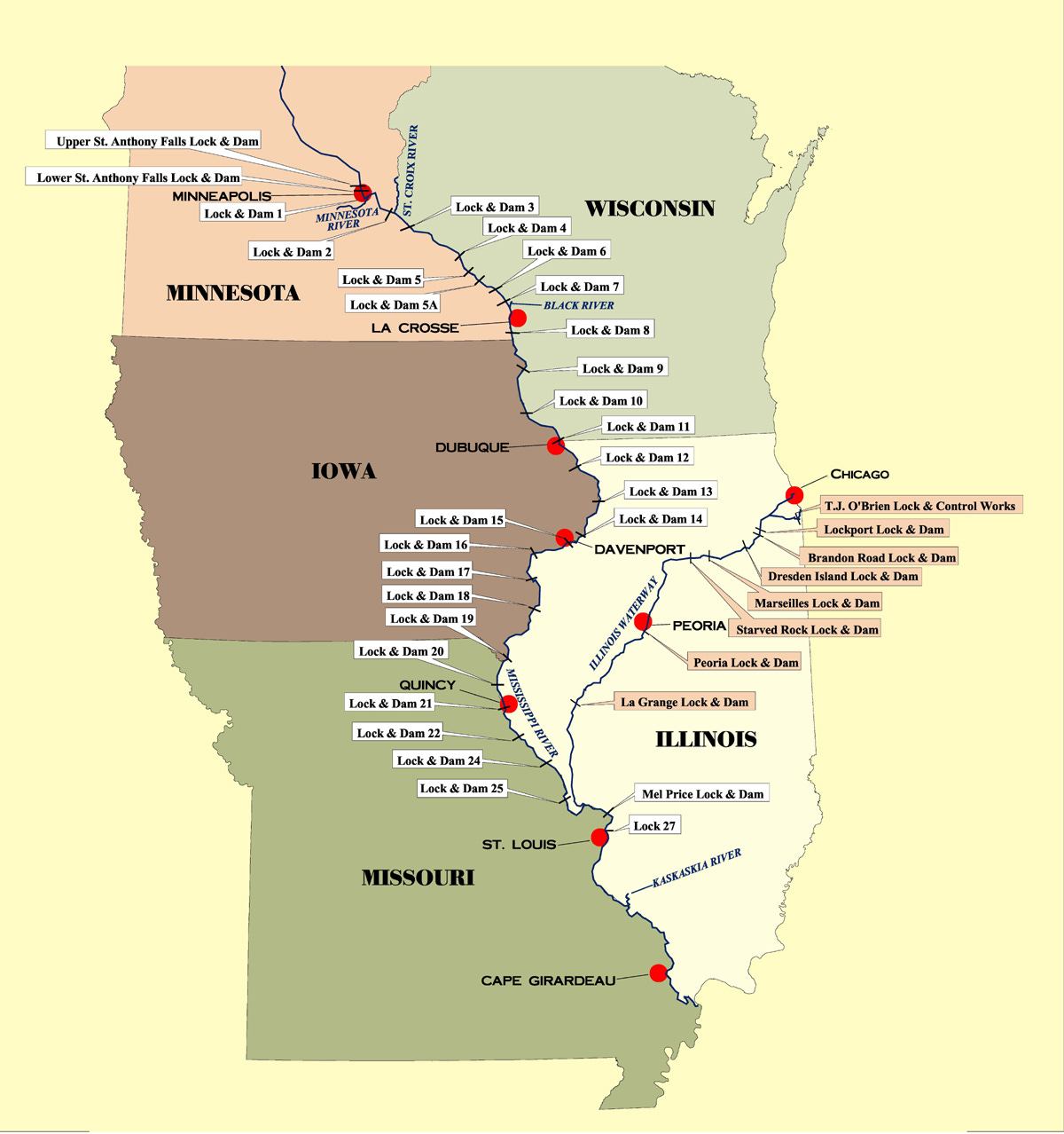
From Lake Itasca, the source of the river to Minneapolis MN and onto St Louis MO, 43 locks and dams moderate the river’s flow. After downtown Minneapolis, 29 dams and locks were constructed to improve commercial navigation of the upper river. The uppermost lock and dam on the Upper Mississippi River is the Upper St. Anthony Falls Lock and Dam in Minneapolis and is considered the point where the navigable river starts. By the time the Upper Mississippi reaches Saint Paul, Minnesota, below Lock and Dam No. 1, it has dropped more than half its original elevation and is 687 feet (209 m) above sea level. From St. Paul to St. Louis, Missouri, the river elevation falls much more slowly and is controlled and managed as a series of pools created by the locks and dams.
The Middle Mississippi River
The Middle Mississippi River runs from the river's confluence with the Missouri River at St. Louis, MO, for 190 miles (310 km) to its confluence with the Ohio River at Cairo, IL. This section of the river is fairly free flowing.
The Lower Mississippi River
The Lower Mississippi River from its confluence with the Ohio River to its mouth at the Gulf of Mexico, a distance of about 1,000 miles (1,600 km). There are no locks or dams on the Lower Mississippi and levees and dikes are used to control flooding and secure a navigation channel for barges.
Mark Twain
I cannot think about transportation and the Mississippi without thinking about Mark Twain. Many years ago I read his “Life on the Mississippi” and I remember how he explained the river was constantly changing, no trip up or down was the same. The depth, currents, eddies changed on each trip. He was traveling the Mississippi nearly 100 years before the Army Corps of Engineers worked on improving navigation on the MSR. I still like to think that there are similar challenges for tugboat pilots today. Samuel Clemens (Mark Twain was his penname) was born in Hannibal MO and he went on the river to be a steamboat pilot. The river at that time was not navigable for anything requiring a deep draft.
River Challenges
A boat's draft is the distance between the waterline and the deepest point of the boat. If a boat goes into too shallow water for its draft, it will become grounded. Thus, for navigation, a clear channel is needed for barges and other vessels. The task of maintaining a navigation channel is the responsibility of the United States Army Corps of Engineers. The first navigable channel cleared was in 1878 and was four and a half feet deep. The current navigable channel was built in the 1930s and allows barges with a 9 foot (3 m) draft to pass down the river. In the Upper Mississippi, there are many areas where the river is not deep enough and no more dredging could occur, so locks and dams were put in.
Aging infrastructure and seasonally changing water levels slow down and stop river traffic. Any shipping delays add to the cost of shipping for the farmer.
Locks and Dams
I am more familiar with English canal locks, which allow boats to travel down or up a gradient while holding the water back. Canals in England, unlike rivers, have no gradient and they do not flow. I am sure canals flow and are fed water a little from springs and streams, but if they flowed like rivers, the water would end up flowing out to sea and not being replenished.
Rivers like the Mississippi are constantly replenished as many springs, streams, and other rivers feed them water. Yet a river occasionally runs dry. Dams hold the water back on the steepest part of the river and the locks help the barges travel around the dams. The navigable part of the Upper Mississippi River has 29 locks and dams to help keep the water deep enough for navigation.
Water Levels
The water levels in the MRS are seasonal, with the highest discharge rates typically being in April after winter snow melts and the lowest levels being in October. Some years the spring river is too high and dangerous and there is severe flooding.
Both high and low water slows down transportation on the MRS. As recently as in October 2022, the water levels at Cairo IL, were the lowest they had been since 1901, and were too low for navigable traffic to pass down the river. A flash drought caused low water in the central U.S. over the Mississippi River itself, increasing evaporation and reducing Lower Mississippi River water levels. A flash drought is the rapid onset or intensification of drought caused by lower-than-average rainfall with abnormally high temperatures, winds, and radiation. At one point, over 2000 barges were backed up with some that had run aground. An estimate suggests that the low levels contributed to about $20 billion in economic losses.
In April 2023, two locks on the Upper Mississippi were shut because of flooding. The main reasons causing higher than usual water levels were: Abnormally deep snowpack at the headwaters of the Mississippi and feeder rivers; a cold March so the usual gradual snow melt didn’t happen; a warm start to April lead to a quick snow melt and a wet April adding rainfall.
Just this past week (July 25 2023), there were warnings that the MRS was getting low again. Both in Cairo, IL and St Louis MO, there were concerns that the Midwest droughts and the lower than usual rains in the East reduced the water reaching the river. A major concern is the Ohio River.
The high and low water levels on the Mississippi are only going to get worse as the weather gets less reliable because of the climate crisis.
Aging Infrastructure
Most of the infrastructure on the river was built in the 1930s and many need repair. They are also too small for the current needs of the river. Most locks are 600 feet long and most barge transports are twice that. Thus, each tugboat must go through each lock twice before moving on down river.
There is concern that containing the river with the levees, in particular, causes some of the extreme winter flooding and the recent low water levels. There is also concern that this is causing a biodiversity loss.
When a lock is closed because of essential repairs, it backs up the whole transportation system and delays grain transport. According to the Army Corps of Engineers, there were 5,000 hours of unscheduled maintenance closures between 2015 and 2019
The recent Infrastructure Investment and Jobs Act gave the Army Corps of Engineers $808 Million for work on the Mississippi river and its tributaries. They divided this between responding to emergency and studies, constructions, operations and maintenance.
Resources about Mississippi River Traffic
One of the reasons I got so involved in this topic is due to how much information is available. You can track river traffic using GPS and satellite maps. I feel you could stalk a tugboat or barge as it travels down and up the rivers.

Every week, the USDA Agricultural Marketing Service releases a Grain Transportation report. These include grain news across the US and internationally and include all forms of grain transportation news. In the most recent one for July 27 2023, I found out the barge freight rate ($26.12/ton if starting in the Twin Cities) and how much grain was shipped down the river that week (169, 000 tons corn and 172, 000 tons soy).
Conclusion
Our food is transported by barge, container ship, train, truck, and plane. To strengthen our food supply chain, we must make sure our transport infrastructure, from Mississippi locks to highway bridges, is maintained and renewed regularly. It isn’t just transportation; our water treatment works were mostly built in the early 1900s and while the processes of water treatment have improved, there has been no change to the systems feeding them and ensuring our water is safe.
Infrastructure doesn’t just mean hardscaping; roads, locks, bridges, reservoirs. It also means communication technology, electrical grids, renewal energy generation, hospitals, etc. Many parts of America have insufficient internet and telephone technology. This leaves them without resources that others take for granted. You cannot order online if you don’t have internet and this limits your access to medical care, jobs, and food.
Resources
General Background
The struggle to control the Mississippi River can help us understand the U.S. - Washington Post
How the Mississippi River Made Mark Twain… And Vice Versa | Travel| Smithsonian Magazine
Transportation Research & Analysis | Agricultural Marketing Service
Breakdown: Why Mississippi River levels are elevated (image of the MRS)
Mississippi River Facts - Mississippi National River & Recreation Area (U.S. National Park Service)
Mississippi River and Waterborne Freight | Bureau of Transportation Statistics (transportation facts)
Water levels
Mississippi River Levels | 67% of Normal Streamflow - SNOFLO (seasonal flow rate; paid site).
Spring flooding
Summer drought
Army Corps of Engineers closely monitoring Mississippi River amid drought conditions
America’s Most Crucial Waterway Is Drying Out | SupplyChainBrain


What a coincidence: my mother grew up by St. Kate's and went to university there. When I was young, we would regularly bike along the Mississippi. Once, I swung on a rope out over it (not particularly safe!).